


Corporate GIS

Corporate GIS is based on common and consistent creation, access, management of spatial data within the organization and between branches and subsidiaries. Corporate GIS is a tool that enables the integration of all information flows and information systems organizations using spatial data for solving analytical tasks, forecasting and modeling.
The key difference between corporate GIS from the regular desktop GIS is the ability to work and maintain a single geodata bank in a multiuser environment, in different software shells in the interest of the organization. The created geodata bank usually involves a large amount of information on various aspects of the organization function, long-term data records and statistical information.
Design of a corporate GIS is usually done with regard to the principle of scalability: functional units, allowing connection of new users to reach a wider territory or increase system performance can be added in the existing workflow as required.
- there is a huge task, which involves several GIS, DBMS;
- work is carried out in disparate branches of the same enterprise;
- a centralized unified environment is required;
- work is being done by a large number of specialists simultaneously within the same project.
SOVZOND Company has successful experience of implementation of projects on creation of corporate GIS in various thematic content in sectors of the economy, the federal, regional and municipal management.
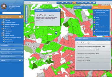
An illustrative example of implementation of a corporate GIS is a project to create . Integrated automated information system of maintenance of town-planning activity is a complete system for automation of various processes related to the functioning of integrated automated information system of maintenance of town-planning activity: registration and control of applications, search and delivery of documents, record books, interaction with related organizations via communication channels, etc. Information on land plots is presented graphically (objects on a map), and in the form of supporting documents and reference books. In addition, the possibility of transition from the documents and references to the corresponding object on the map and vice-versa is realized.
Other examples of completed projects on building corporate GIS can be found in section GB GIS.